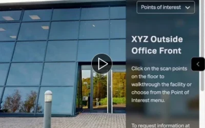
XYZ Machine Tools and ZUANT 3D
This artice posted on LinkedIn speaks about our involvement with producing the virtual tour of their extensive facilities – contact us to find out more.

Stop imagining the site. See it. Decide.
If you lead design, manage construction, or carry estates responsibility, you already produce excellent drawings and specifications. Where projects wobble is not the model – it’s the gap between model and field reality.
Email threads, PDFs and phone photos force everyone to reconstruct the site in their heads. That’s slow. It’s stressful. And it’s risky.
A 360° / 3D tour changes one thing fundamentally:
It gives every stakeholder the same visual truth. One link. Same context.
This is not about replacing BIM or CAD. It’s about adding a reality layer beneath them.
You already model brilliantly. We simply document what is actually there – accurately, time-stamped, and shareable.
Think of it as:
From Site to Insight. One space. One story. One truth.
For teams who assume it’s expensive or complicated, the reality is this:
a modest capture cost often removes hours of travel, rework and miscommunication later. It pays for itself in saved time alone.
We keep it simple and precise.

LiDAR scanning provides a full dolls house model and precise floor plan for reliable insurance assessments.
We use the Matterport Pro3 LiDAR camera to scan the space.
We typically:
Result: a complete, measurable digital twin of the site as it is today.
After capture, we publish a secure 3D link and, where required, provide technical exports.
This is what turns “I think” into “I can see”.
When your team needs more than viewing:
E57 Point Cloud (ASTM E2807)
Workflow example:
E57 → Autodesk ReCap (RCP/RCS) → AutoCAD / Revit link
Revit Plug-in Route
Optional BIM / CAD Deliverables
The key distinction:
We keep those roles clean to avoid workflow confusion.
A space isn’t static. That’s where staged capture matters.
We rescan at key milestones and enable:
Ideal for:
Instead of asking, “What was there when we agreed that?”, you just step back in time.
A 3D tour is not the end product. It’s the foundation.
SimLab STAGES
Perfect when coordination and version control matter more than pure modelling.
SIM-ON
Turns a scan into a living operational interface.
For commercial property, hospitality or exhibition environments:
The same model that supports coordination can also support sales.
A digital twin is not just convenient – it supports measurable ESG outcomes.
This is not about technology for its own sake.
It’s about:
You already design and manage complex spaces. We simply ensure that what’s built, changed, agreed or disputed is documented in a way that stands up.
Show — don’t second-guess.

Publishing a Google Street View tour lets customers see your business before they visit, directly from Google Search and Google Maps. For many organisations, it’s one of the simplest ways to improve visibility, trust and engagement online.
A Street View tour appears within your Google Business Profile, Maps listing and local search results. This helps your business stand out from competitors and encourages more people to click through to your listing.
Result: more profile views, more directions requests, more enquiries.
Customers can explore your premises in advance, understand the layout and get a feel for the environment. This is especially valuable for venues where atmosphere, accessibility or scale matter.
Result: fewer uncertainties, stronger first impressions, better-qualified visitors.
Street View helps people decide whether your business is right for them before they arrive. For hospitality, retail, leisure and healthcare settings, this often leads to higher-quality visits and fewer wasted enquiries.
Result: visitors arrive with clearer expectations and greater intent.
Your Street View tour works 24/7, showing your space even when you’re closed. It’s also easier to update than traditional photography if your space changes.
Result: a long-lasting digital asset with ongoing value.
Google favours rich, visual listings. Businesses with Street View tours often see improved engagement metrics, which can support better local search performance over time.
Result: stronger local presence without ongoing ad spend.
Street View works alongside your website, social media and full 3D virtual tours. It’s often the first touchpoint, leading people into deeper engagement elsewhere.
Result: a smoother journey from discovery to visit.
At EC2XRwe offer a fixed rate for Google Street View of £250 + VAT, which includes one site visit, high-quality 360 tour photography, plus integration on your Google Business profile.

You’ve probably seen 360° virtual tours online — the kind where you can click, move and explore a space as if you’re there. But how do they actually work, and why are so many businesses using them to showcase their spaces?
At EC2XR, we create interactive 3D virtual tours that let people explore real environments remotely, on any device. Unlike video or photography alone, a virtual tour gives viewers control. They choose where to look, where to move next, and what information to open — creating a far more engaging experience.
Step 1: Capturing the Space
We visit your venue and capture it using professional 360 cameras and LiDAR scanning. This records the space exactly as it is — including layout, proportions and detail — whether it’s a shop, hotel, gym, restaurant or large commercial site. Indoor and outdoor areas can be linked into one continuous experience.
Step 2: Building the Virtual Tour
The captured data is processed into a navigable 3D model. From there, we add interactive elements such as information points, images, videos, menus, pricing, floor plans or links. These sit naturally inside the space, allowing visitors to learn as they explore.
Step 3: Sharing Everywhere
Once complete, your tour can be shared with a simple link or embedded directly into your website, listings or social media. It works on desktop, mobile and tablets — no apps or headsets required.
Why Businesses Use Virtual Tours
Virtual tours help customers understand your space before they arrive. They set expectations, build confidence and often shorten the journey from interest to action. Many clients also reuse the same tour for staff training, inductions and internal planning.
In short, a 360 virtual tour turns your physical space into a digital asset — always open, always accessible, and always working for your business.
If you’ve invested time and money creating a great environment, a virtual tour lets the world experience it properly.
Read more about how this would work in your sector HERE
Or better still, contact us for a chat about your specific requirements…

EC2XR provides LiDAR-based 3D scans and virtual tours that give insurers, adjusters and restoration teams an exact visual record of commercial properties. From warehouses and retail units to offices, schools, hospitality spaces and industrial sites, LiDAR scanning delivers clarity, accuracy and transparency at every stage of a claim.
Accurate measurements, instantly
LiDAR captures detailed geometry of your building, fixtures, equipment and contents. Every measurement is precise, consistent and reviewable long after the site visit.
A complete digital record
Loss adjusters, restoration teams and insurers can revisit the site virtually — reducing travel, speeding decisions and supporting ESG goals.
Ideal for fire, flood and impact damage
Scans can be completed quickly, even in difficult conditions, creating a permanent record before remediation begins.

Collage of four interiors from different sectors
Xactimate Compatibility
Our scans can be converted into Xactimate-ready assets, enabling faster and more reliable estimating. Adjusters can pull measurements, areas and volumes directly into their calculation models.
TruePlan for Xactimate
We can supply TruePlan outputs — professionally produced floor plans, elevations and CAD assets generated from the scan data. These speed up the reinstatement process and reduce errors.
Sketch & Floor Plans
For insurers needing a simple floor plan, we can deliver clean, accurate Sketch plans alongside the 3D tour and LiDAR model.
OBJ, E57 and MatterPak
For technical teams, architects and restoration contractors, we provide:
We deliver high-fidelity scans across the UK, with minimal disruption to operations.
Perfect for pre-loss risk documentation and post-loss evidence capture.
Call us now on 020 8123 9360 or use our contact form

When something goes wrong at home — a leak, a fire, a storm, or unexpected structural damage — the last thing anyone wants is a complicated insurance process. The challenge is simple: insurers need clear evidence, accurate measurements and reliable information, while homeowners want a straightforward, stress-free assessment.
This is exactly where LiDAR scanning is now helping thousands of homeowners across the UK.
LiDAR isn’t new. It’s used in engineering, surveying and architecture every day. But in the world of home insurance, it has quietly become one of the most effective tools for documenting damage quickly, clearly and accurately.
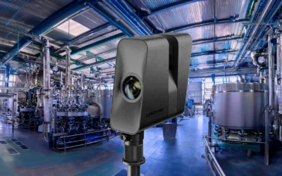
What is LiDAR scanning?
LiDAR (Light Detection and Ranging) uses laser-based measurement to build a precise 3D model of your home. It captures the layout, structure, fixtures and damage with exceptional accuracy — much more reliable than photographs alone.
The result is a fully interactive 3D walkthrough of your property that insurers, adjusters and contractors can explore without needing multiple home visits.
Why LiDAR helps homeowners during a claim
LiDAR creates an exact, time-stamped record of your home. Whether it’s fire damage, an escape-of-water or a fallen tree, nothing is missed or mis-measured.
Loss adjusters and contractors can assess the space remotely. Fewer visits. Fewer delays. Less stress for you.
LiDAR captures everything quickly — even before drying, strip-out or emergency works begin. You get evidence at the moment you need it most.
EC2XR can supply outputs that slot straight into insurance systems, including:
These aren’t extras — they speed up decisions and reduce the risk of disputes.
With a detailed virtual record, you don’t have to worry about forgotten rooms, missing details or unclear damage descriptions. Everything is captured once and reviewed as many times as needed.
A simple, respectful process
LiDAR scanning is quick and non-intrusive. Most homes are documented in under 60–90 minutes. EC2XR works sensitively in lived-in or damaged environments, providing clear communication throughout.
A better way to start the insurance process
For homeowners, LiDAR removes uncertainty. For insurers, it reduces friction. And for everyone involved, it delivers clarity — exactly when it’s needed.
If you’ve recently experienced damage at home or want to protect yourself with a pre-loss digital record, EC2XR can help.